
Danube basin: flood, low flow, hydrometeorological conditions, water quality

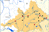
The River Danube is formed at the confluence of the Rivers Breg and Brigach in the Black Forest near Donaueschingen and flows into the eastern Black Sea via an extensive delta. With a length of 2857 km, it is the second longest river in Europe. The international river basin district Danube, in which 19 states participate, covers an area of 807827 sq. km. It includes the catchment area of the Danube (801463 sq. km), and also smaller areas on the coast of the Black Sea. 7 % of the Danube river basin district are within Germany, 1 % in Baden-Württemberg (around 8050 sq. km) and 6 % (around 48200 sq. km) in Bavaria. [1]
The largest tributaries of the Danube are March (Morava), Váh, Tisza, Olt, Sereth, Pruth on the left side and Lech, Isar, Inn, Traun, Enns, Drau, Save, Morava (Serbia) and Iskar on the right side.
Hydrologically, the Danube can be divided into three sections: the upper section to the Porta Hungarica including the Morava tributary (March), the middle section to the Iron Gate between the Southern Carpathians and the Balkan Mountains (Stara Planina) and the lower section with the delta to the Black Sea.
The upper Danube section is divided into eleven planning areas according to the international coordination on the implementation of the EU Water Framework Directive, which are split among six countries. Germany is responsible for the planning areas "Danube (Baden-Württemberg)", "Iller-Lech", "Altmühl-Paar", "Isar", "Naab-Regen" and "Inn".
The River Basin Community Danube (FGG Donau) and - with the participation of Germany - the following international or bilateral commissions / working groups are committed to water protection and flood risk management of the Danube and its tributaries:
- ICPDR - International Commission for the Protection of the Danube River
- German - Austrian Commission on Border Rivers
- German - Czech Commission on Border Rivers
- IAD - International Association for Danube Research
- IAWD - International Association of Water Service Companies in the Danube River Catchment Area
Danube:
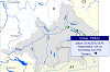
Selection of gauges / water quality monitoring stations
Danube:
Current hydrometeorological conditions
Danube:
Extreme floods / low flows
Danube:
Current water temperature / oxygen content
Overview Danube basin
- ICPDR / IKSD: Danube Basin - River Basin
- ICPDR / IKSD (2005): Danube Basin Analysis (WFD Roof Report 2004)
- Bundesministerium für Umwelt, Naturschutz und Reaktorsicherheit (Hrsg.) (2000 - 2003): Hydrologischer Atlas von Deutschland (HAD)
- Bayerisches Landesamt für Wasserwirtschaft (Koordinator) (2005): Bericht zur Bestandsaufnahme gemäß Art. 5, Anhang II und Anhang III, sowie Art. 6, Anhang IV, der WRRL für das Deutsche Donaugebiet
Water quality
- [1] ICPDR / IKSD (2021): Danube River Basin District Management Plan
- FGG Donau (Hrsg.) (2021): Bewirtschaftungsplan Donau - Bewirtschaftungszeitraum 2022 bis 2027
- Landesanstalt für Umwelt Baden-Württemberg: Fließgewässerdaten der Online-Messstellen
- Bayerisches Landesamt für Umwelt: Niedrigwasser-Informationsdienst: Gewässerqualität
- Bayerisches Landesamt für Umwelt: Gewässerkundlicher Dienst Bayern: Chemie der Flüsse
- Umweltbundesamt (Hrsg.) (2017a): Gewässer in Deutschland: Zustand und Bewertung
- Umweltbundesamt (Hrsg.) (2017b): Wasserwirtschaft in Deutschland - Grundlagen, Belastungen, Maßnahmen
- Umweltbundesamt (Hrsg.) (2022): Die Wasserrahmenrichtlinie - Gewässer in Deutschland 2021
- Umweltbundesamt (Hrsg.): Geographisches Informationssystem Umwelt
- European Environment Agency: Water quality monitoring stations (Karte der Messstellen der Wasserbeschaffenheit (Flüsse [und Kanäle], Seen [und Talsperren], Grundwasser, Küsten- und Übergangsgewässer, Meer) für die EU-Berichterstattung)
- European Environment Agency: Waterbase - Water Quality (Daten zur Wasserbeschaffenheit der Gewässer in Europa)
Flood / low flow
- ICPDR / IKSD: Floods
- ICPDR / IKSD (2021): Flood Risk Management Plan for the Danube River Basin District
- FGG Donau (Hrsg.) (2021): Hochwasserrisikomanagementplan der Flussgebietseinheit Donau 2022 bis 2027
- Bayerisches Staatsministerium für Umwelt und Verbraucherschutz: Hochwasserdialog Bayern
- ICPDR / IKSD: Droughts
- Bayerisches Landesamt für Umwelt: Niedrigwasser-Informationsdienst Bayern
- Bayerisches Landesamt für Umwelt: Niedrigwasser-Informationsdienst Bayern: Ereignisse
- Bundesanstalt für Gewässerkunde: Hochwassergefahren und -risikokarten (für alle Bundesländer)
The Danube in Austria and other countries
- Austria
- via donau: Österreichische Wasserstraßen-Gesellschaft
- DoRIS: Service- und Informationsseiten für Schifffahrtstreibende auf der Donau
- Bundesministerium für Land- und Forstwirtschaft, Umwelt und Wasserwirtschaft: eHYD - Informationssystem zur Hydrographie Österreichs
- Land Vorarlberg: Aktuelle Niederschläge, Wasserstände, Durchflüsse
- Land Tirol: Hydro Online
- Land Salzburg: HYDRIS ONLINE Messdatenbereitstellung
- Land Oberösterreich: Lagebericht, Aktueller Wasserstand
- Land Niederösterreich: Wasserstandsnachrichten, Hochwasserprognosen
- Czech Republic
- Povodí Moravy, státní podnik: Hydrologische Situation
- Ceský hydrometeorologický ústav: Hochwasservorhersage; Hydrologische Situation
- Slovak Republic
- Slovenský vodohospodársky podnik: Hydrologische Situation Donau
- Slovenský hydrometeorologický ústav: Meteorologischer und hydrologischer Überblick
- Switzerland
- Bundesamt für Umwelt: Hydrologische Grundlagen und Daten
- Hungary
- Országos Vízjelzo Szolgálat: Überblickskarte Wasserstände
- Slovenia
- Agencija Republike Slovenije za okolje: Überblickskarte Wasserstände, Durchflüsse
- Croatia
- Hrvatske vode: Überblick Wasserstände und Durchflüsse
- Centar za razvoj unutarnje plovidbe: Wasserstände Donau, Drava, Sava
- Serbia
- Republicki hidrometeorološki zavod Srbije: Hydrologische Daten und Vorhersagen
- Romania
- Administratia Fluviala a Dunarii de Jos: Schifffahrtsverwaltung Untere Donau ... Wasserstände und weitere Informationen
- Bulgaria
- Agentur zur Erforschung und Erhaltung der Donau: Wasserstand und Wassertemperatur der Donau
Research projects / programmes
- IDES - Improving water quality in the Danube river and its tributaries by integrative floodplain management based on Ecosystem Services. Interreg Danube Transnational Programme; Lead partner: Catholic University of Eichstaett-Ingolstadt, Förderung: EU, Laufzeit 2020 - 2022
- WETRAX+: (WEather Patterns, Cyclone TRAcks and related precipitation EXtremes) - Auswirkungen des Klimawandels auf großflächige Starkniederschläge in Süddeutschland und Österreich: Analyse der Veränderungen von Zugbahnen und Wetterlagen und ihre Wirkung auf die Hydrologie (Fortführung des Vorgängerprojektes WETRAX); Projektpartner: Zentralanstalt für Meteorologie und Geodynamik (ZAMG), TU Wien - Institut für Wasserbau und Ingenieurhydrologie, Universität Augsburg - Institut für Geographie; Projektträger: Österreichisches Bundesministerium für Nachhaltigkeit und Tourismus, Bundesanstalt für Gewässerkunde (BfG), LfU Bayern, Laufzeit 2018 - 2021
- Danube Floodplain - Reducing the flood risk through floodplain restoration along the Danube River and tributaries. Interreg Danube Transnational Programme (DTP); Koordinierung: National Administration "Romanian Waters", Bukarest , Förderung: EU, Laufzeit 2018 - 2020
- DanubeSediment - Danube Sediment Management - Restoration of the Sediment Balance in the Danube River. Interreg Danube Transnational Programme (DTP); Koordinierung: Technische und Wirtschaftswissenschaftliche Universität Budapest , Förderung: EU, Laufzeit 2017 - 2019
- Danube:Future - A sustainable future for the Danube River Basin as a challenge for the interdisciplinary humanities. Flagship Project of the EU Strategy for the Danube Region (EUSDR); Koordinierung: Alpen-Adria-Universität Klagenfurt, Förderung: EU, Laufzeit 2013 - 2020
- DANUBIUS-RI Danube International Centre for Advanced Studies for River-Sea Systems. Flagship Project of the EU Strategy for the Danube Region (EUSDR); Koordinierung: Rumänien
- KLIWAS: Auswirkungen des Klimawandels auf Wasserstraßen und Schifffahrt in Deutschland; Programmkoordinierung: BfG, Programmpartner DWD, BSH, BAW, BfG; Träger: BMVBS, Laufzeit 2009 - 2013
- KLIWA: Klimaveränderung und Wasserwirtschaft; Koordinierung: Steuerungsgruppe KLIWA (DWD, Bundesländer: BW, RP, BY), Laufzeit seit 1999
- Strategie der Europäischen Union für den Donauraum / Masterplan Donauraum Bayern; Koordinierung: Bayerisches Umweltministerium (Schwerpunktbereich: Erhaltung der biologischen Vielfalt, der Landschaften und der Qualität von Luft und Boden). Stand: August 2017 (Masterplan)