
Ems basin: flood, low flow, hydrometeorological conditions, water quality

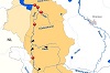
The River Ems flows through the North German Plain at first in a northwesterly direction - draining the Teutoburg Forest to the west - and then to the north. After 371 river km it flows into the North Sea at Emden. The international river basin district of the Ems encompasses the Ems-Dollart estuary, the Dutch Nedereems area and the German Ems area - totaling about 18000 sq. km. Around 84 % of the total area is located in Germany (61 % in Lower Saxony and 23 % in North Rhine-Westphalia), 13 % in the Netherlands and 3 % in the international area of the Ems-Dollart-Estuary. The main tributaries of the Ems are the Hase and the Leda.[1]
Parts of the impounded Middle Ems are sections of the Dortmund-Ems Canal (DEK). With its confluence close to Meppen, the previous chainage of the Ems as a federal waterway (km 0 at the weir Schöneflieth, Greven) is replaced by the chainage of the DEK (Ems km 124.15 changes to Ems km 166.59 DEK). The Herbrum lock (Ems-km 212.6 DEK) represents the tidal limit. From km 225.82 DEK near Papenburg the Lower Ems starts at kilometer 0.00, then merges into the Outer Ems (maritime waterway) at km 67.76 and reaches the North Sea island of Borkum at km 92.0.
The following international and national commissions / working groups advocate for water protection and flood risk management on the Ems and its tributaries:
Ems:
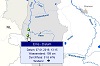
Selection of gauges / water quality monitoring stations
Ems:
Current hydrometeorological conditions
Ems:
Extreme floods / low flows
Ems:
Current water temperature / oxygen content
Overview Ems basin
- FGE Ems: Die Ems
- FGE Ems (Hrsg.) (2005): Bericht ("Teil A") der internationalen Flussgebietseinheit Ems
- Bundesministerium für Umwelt, Naturschutz und Reaktorsicherheit (Hrsg.) (2000 - 2003): Hydrologischer Atlas von Deutschland (HAD)
Water quality
- [1] FGE Ems (Hrsg.) (2021): Internationaler Bewirtschaftungsplan für die Flussgebietseinheit Ems
- FGE Ems (Hrsg.) (2007): Bericht zu den Überwachungsprogrammen gemäß Wasserrahmenrichtlinie in der Flussgebietseinheit Ems
- Niedersächsischer Landesbetrieb für Wasserwirtschaft, Küsten- und Naturschutz: Landesdatenbank für wasserwirtschaftliche Daten | Chemische Gewässergüte Einzugsgebiet Ems (Gütekarten 1985 - 2005)
- Ministerium für Umwelt, Landwirtschaft, Natur- und Verbraucherschutz Nordrhein-Westfalen: Wasserinformationssystem ELWAS
- Landesamt für Natur, Umwelt und Verbraucherschutz Nordrhein-Westfalen: HYGON (Hydrologische Rohdaten Online)
- Umweltbundesamt (Hrsg.) (2017a): Gewässer in Deutschland: Zustand und Bewertung
- Umweltbundesamt (Hrsg.) (2017b): Wasserwirtschaft in Deutschland - Grundlagen, Belastungen, Maßnahmen
- Umweltbundesamt (Hrsg.) (2022): Die Wasserrahmenrichtlinie - Gewässer in Deutschland 2021
- Umweltbundesamt (Hrsg.): Geographisches Informationssystem Umwelt
- European Environment Agency: Water quality monitoring stations (Karte der Messstellen der Wasserbeschaffenheit (Flüsse [und Kanäle], Seen [und Talsperren], Grundwasser, Übergangs-, Küsten- und Meeresgewässer) für die EU-Berichterstattung)
- European Environment Agency: Waterbase - Water Quality (Daten zur Wasserbeschaffenheit der Gewässer in Europa)
Dutch Eems basin
Flood / low flow
- FGE Ems (Hrsg.) (2015): Internationale Koordinierung der Umsetzung der Hochwasserrisikomanagement-Richtlinie in der Flussgebietseinheit Ems
- FGG Ems (Hrsg.) (2021): Hochwasserrisikomanagementplan 2021-2027 für den deutschen Anteil der Flussgebietseinheit Ems gemäß § 75 WHG
- Niedersächsischer Landesbetrieb für Wasserwirtschaft, Küsten- und Naturschutz: Informationsportal Hochwasserschutz
- Landesamt für Natur, Umwelt und Verbraucherschutz Nordrhein-Westfalen: Hochwasserschutz
- Bundesanstalt für Gewässerkunde: Hochwassergefahren und -risikokarten (für alle Bundesländer)
Research projects / programmes
- Masterplan Ems 2050: Ökologie und Ökonomie - gemeinsam für die Emsregion; Koordinierung: Geschäftsstelle Masterplan Ems, Laufzeit seit 2015
- Programm Ems-Dollart 2050: Mehrjähriges adaptives Maßnahmenprogramm zur ökologischen Verbesserung; Projektleitung: Niederländisches Ministerium für Wirtschaft, Rijkswaterstaat Noord-Nederland, Provinz Groningen, Umsetzung seit 2016 (Phase 1 2016 - 2020, Phase 2 2021 - 2026)
- Projekt EmsLand: Auenentwicklung an der Ems zwischen Salzbergen und Dörpen; Projektträger: Landkreis Emsland; Förderung durch Bundesumweltministerium (Blaues Band Deutschland: Förderprogramm Auen) und Land Niedersachsen; Laufzeit: 1.10.2022 bis 30.9.2028