
Rhine basin: flood, low flow, hydrometeorological conditions, water quality

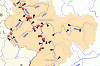
The River Rhine originates in the Swiss Alps and flows through the Rhine delta (main branches are Waal, Nederrijn and Ijssel) into the North Sea in the Netherlands. Its total length is 1232.7 km (CHR 2015), with approximately 870 km in Germany. The Rheinstrom chainage used for shipping and navigation starts at the Rhine bridge in Konstanz (km 0.0) and ends at Hoek van Holland (km 1032.8). The German federal states Baden-Württemberg, Bavaria, Rhineland-Platinate, Saarland, Hesse and North Rhine-Westphalia are completely (Rhineland-Platinate, Saarland) or partially located in the Rhine basin. Very small areas belong to Thuringia and Lower Saxony.
The area of the International River Basin Destrict Rhine amounts to around 200000 sq. km (Germany 54 %, Netherlands 17 %, Switzerland 14 %, France 12 %, Luxembourg 1 %, Austria 1 %, Belgium, Liechtenstein and Italy each < 1 %. The main tributaries of the Rhine are the Aare, the Neckar, the Main and the Moselle. Other important tributaries are Ill, Nahe, Lahn, Sieg, Ruhr and Lippe. [1]
The following international and national commissions / working groups advocate for water protection and flood risk management on the Rhine and its tributaries:
- ICPR - International Commission for the Protection of the Rhine
- ICPMS - International Commissions for the Protection of the Moselle and Saar
- IGKB - International Commission for water protection of Lake Constance
- CHR - International Commission for the Hydrology of the Rhine basin
- FGG Rhein - River basin community Rhine
Rhine:
Selection of gauges / water quality monitoring stations
Rhine:
Current hydrometeorological conditions
Rhine:
Extreme floods / low flows
Rhine:
Current water temperature / oxygen content
Rhein:
Current electric conductivity / pH-value
Rhine:
Longterm trend of selected substances
Overview Rhine basin
- FGG Rhein: Der Rhein
- Koordinierungskomitee Rhein / IKSR (2005): Internationale Flussgebietseinheit Rhein - Merkmale, Überprüfung der Umweltauswirkungen menschlicher Tätigkeiten und wirtschaftliche Analyse der Wassernutzung. - Bericht an die Europäische Kommission [gemäß Art. 15, Abs. 2, 1. Anstrich der Richtlinie 2000/60/EG (A-Bericht)]
- Bundesministerium für Umwelt, Naturschutz und Reaktorsicherheit (Hrsg.) (2000 - 2003): Hydrologischer Atlas von Deutschland (HAD)
Water quality
- [1]Koordinierungskomitee Rhein / IKSR (2009 / 2015 / 2021): International koordinierter Bewirtschaftungsplan für die internationale Flussgebietseinheit Rhein
- IKSR: Sedimentmanagementplan Rhein
- Koordinierungskomitee Rhein / IKSR (2007): Bericht über die Koordinierung der Überwachungsprogramme gem. Artikel 8 und Artikel 15 Abs. 2 WRRL in der internationalen Flussgebietseinheit (IFGE) Rhein (Teil A – Bericht)
- IKSR (Hrsg.): IKSR-Zahlentafeln (Datenbank)
- IKSMS: Wasserqualität der Gewässer Mosel und Saar
- FGG Rhein (Hrsg.): Zahlentafeln der chemisch-physikalischen Untersuchungen (Datenbank)
- Ministerium für Umwelt, Landwirtschaft, Natur- und Verbraucherschutz Nordrhein-Westfalen: Wasserinformationssystem ELWAS
- Landesamt für Natur, Umwelt und Klima Nordrhein-Westfalen (LANUK): Hochwasserportal.NRW - Hydrologische Daten Online (aktuelle Daten der Messstationen)
- Ministerium für Klimaschutz, Umwelt, Energie und Mobilität Rheinland-Pfalz: Wasserportal (aktuelle Daten der Messstationen)
- Hessisches Landesamt für Naturschutz, Umwelt und Geologie: Messdatenportal (Daten der Messstationen und Messstellen)
- Landesanstalt für Umwelt Baden-Württemberg: Güteparameter der Online-Messstationen | Daten- und Kartendienst der LUBW (Langzeitdaten)
- Universität des Saarlandes, AG Gewässer-Monitoring: Gewässer-Monitoring (aktuelle Messdaten der Saar)
- Umweltbundesamt (Hrsg.) (2017a): Gewässer in Deutschland: Zustand und Bewertung
- Umweltbundesamt (Hrsg.) (2017b): Wasserwirtschaft in Deutschland - Grundlagen, Belastungen, Maßnahmen
- Umweltbundesamt (Hrsg.) (2022): Die Wasserrahmenrichtlinie - Gewässer in Deutschland 2021
- Umweltbundesamt (Hrsg.): Geographisches Informationssystem Umwelt
- Bundesamt für Umwelt (CH): Hydrologische Daten und Vorhersagen (auch Wassertemperatur und aktuelle Wasserbeschaffenheitsdaten von NADUF-Stationen)
- Agence de l'eau Rhin - Meuse (F): Système d'Information sur l'Eau Rhin-Meuse
- European Environment Agency: Water quality monitoring stations (Karte der Messstellen der Wasserbeschaffenheit (Flüsse [und Kanäle], Seen [und Talsperren], Grundwasser, Übergangs-, Küsten- und Meeresgewässer) für die EU-Berichterstattung)
- European Environment Agency: Waterbase - Water Quality (Daten zur Wasserbeschaffenheit der Gewässer in Europa)
Accidental water pollution, warning and alarm plans
- IKSR: Warn- und Alarmplan Rhein
- IKSMS: Internationaler Warn- und Alarmplan Mosel-Saar
- Rijkswaterstaat (NL): Aqualarm Lobith
The Rhine in neighbouring countries
- Austria
- Bundesministerium für Land- und Forstwirtschaft, Umwelt und Wasserwirtschaft: eHYD - Informationssystem zur Hydrographie
- Land Vorarlberg: Aktuelle Niederschläge, Wasserstände, Durchflüsse
- Switzerland
- Bundesamt für Umwelt: Hydrologische Grundlagen und Daten
- France
- Ministère de la Transition écologique et solidaire: Hydrologische Übersichten, Statistiken, Publikationen | Hochwassergefährdungskarte, aktuelle Wasserführung, Pegelstammdaten
- Luxembourg
- Administration de la gestion de l'eau: Hochwasserinformationssystem
- Belgium
- Service Public de Wallonie: Direction générale opérationnelle de la Mobilité et des Voies hydrauliques: Hochwassergefährdungskarte, aktuelle Wasserführung, Pegelstammdaten
- Service Public de Wallonie: Direction générale opérationnelle Agriculture, Ressources naturelles et Environnement: aqualim: hydrometrische Messungen
- Netherlands
- Rijkswaterstaat: Hydrologische Informationen und Daten
- Rijkswaterstaat (Fairway Information Services): aktuelle Wasserstände, Hochwasser-, Niedrigwasser- und Eismeldedienst, Schifffahrtsnachrichten
- RIWA RIJN (Vereinigung von Flusswasser-Unternehmen): Berichte mit Analysendaten zur Wasserqualität
Flood / low flow
- Koordinierungskomitee Rhein / IKSR (2015 / 2021): International koordinierter Hochwasserrisikomanagementplan für die Internationale Flussgebietseinheit Rhein, Teil A
- IKSR (2026): Rheinatlas 2026 (Hochwassergefahren- und -risikokarten der Internationalen Flussgebietseinheit Rhein)
- IKSR: Thema Niedrigwasser
- IKSMS: Thema Niedrigwasser
- IKSMS (2019): Niedrigwasserproblematik im Einzugsgebiet von Mosel und Saar – Aktualisierung der Bestandsaufnahme (Februar 2019)
- Hessisches Landesamt für Naturschutz, Umwelt und Geologie: Hochwasser / Überschwemmungsgebiete
- Landesamt für Natur, Umwelt und Verbraucherschutz Nordrhein-Westfalen: Hochwasserschutz
- Ministerium für Klimaschutz, Umwelt, Energie und Mobilität Rheinland-Pfalz: Hochwassermanagement Rheinland-Pfalz
- Ministerium für Umwelt, Klima und Energiewirtschaft Baden-Württemberg: Hochwasserschutz und -vorsorge Baden-Württemberg
- Hochwassernotgemeinschaft Rhein e.V.: Solidargemeinschaft von Kommunen und Bürgerinitiativen
- Hochwasser Kompetenz Centrum e.V.: Hochwasserschutz-Netzwerk
- Bundesanstalt für Gewässerkunde: Hochwassergefahren- und -risikokarten (für alle Bundesländer)
Research projects / programmes
- Non-target screening in the Rhine basin: Koordination: IKSR; Förderung: EU-Life-Programm, Pilotprojekt: Laufzeit 2021 - 2024; Projekt: Laufzeit 2024 - 2029
- KAHR: Klima-Anpassung, Hochwasser und Resilienz für Rheinland-Pfalz und Nordrhein-Westfalen; Verbundprojekt: 13 nationale Verbundpartner; Förderung BMBF FONA, Laufzeit 2021 - 2024
- DRIeR: Drought impacts, processes and resilience: making the invisible visible; Projektpartner: Universität Freiburg, Universität Heidelberg, Universität Tübingen; Förderung: Ministerium für Wissenschaft, Forschung und Kunst Baden-Württemberg, Laufzeit 2016 - 2020
- Transnationales Hochwasserrisikomanagement im Rheineinzugsgebiet. Ein historisch-progressiver Ansatz. Antragsteller: Prof. Glaser, Universität Freiburg; Förderung: DFG, Laufzeit 2014 - 2017
- ERMES Rhein: Entwicklung der Ressource und Überwachung des Grundwassers im Oberrhein; Projektträger: Association pour la Protection de la Nappe Phréatique de la Plaine d'Alsace; Förderung: Europäischer Fonds für regionale Entwicklung (INTERREG V), Laufzeit 2016 - 2018
- KLIWAS: Auswirkungen des Klimawandels auf Wasserstraßen und Schifffahrt in Deutschland; Programmkoordinierung: BfG, Programmpartner DWD, BSH, BAW, BfG; Träger: BMVBS, Laufzeit 2009-2013
- RIMAX: Risikomanagement extremer Hochwasserereignisse; Koordinierung: GeoForschungsZentrum Potsdam (GFZ), Förderung: BMBF, Laufzeit 2005 - 2010
- Rhein 2040: Programm zur nachhaltigen Entwicklung des Rheins; Koordinierung: IKSR, Laufzeit 2021-2040
- KLIWA: Klimaveränderungen und Wasserwirtschaft; Koordinierung: Steuerungsgruppe KLIWA (DWD, Bundesländer: BW, RP, BY), Laufzeit seit 1999